

The National Weather Service issued a freeze warning for Utah Valley for Wednesday, Oct. 11 through 9 a.m. on Friday, Oct. 13.
Sub-freezing temperatures were expected to drop as low as 28 degrees Fahrenheit, according to the National Weather Service. Temperatures rose above freezing during daylight hours.
The announcement said crops and outdoor plants were in danger of being killed and unprotected outdoor plumbing could be damaged by the low temperatures.
Other parts of Utah affected by the freeze warning included southern Utah County, Rush Valley, the western Uinta Basin, Millard County, Juab County, the Sanpete and Sevier Valleys, southwest Utah and the area around Capitol Reef National Park, especially Bicknell and Loa.
What is a frost advisory vs freeze watch vs freeze warning?
Frost and freeze watches, advisories and warnings are issued from May to October, the typical growing season, when it is uncommon for temperatures to drop low enough to see frosts or freezes.
The National Weather Service defines these alerts as the following:
Frost Advisory: “A Frost Advisory is issued when the minimum temperature is forecast to be 33 to 36 degrees on clear and calm nights during the growing season.”
Freeze Watch: “A Freeze Watch is issued when there is a potential for significant, widespread freezing temperatures within the next 24-36 hours.”
Freeze Warning: “A Freeze Warning is issued when significant, widespread freezing temperatures are expected.”
Are freeze or frost warnings common in October for Provo?
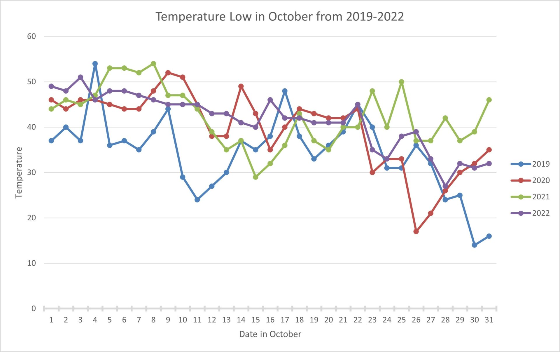
Freezes are typical in October for Provo.
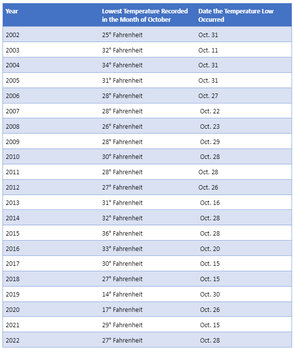
For the last 20 years in Provo, temperatures have dropped below freezing 16 times during October. However, it is more likely for Provo to see freezing temperatures later in the month as opposed to Oct. 11-13.
Since 2002, the earliest Provo has seen below freezing temperatures is Oct. 15.
Current weather reports did not show Provo reaching below freezing temperatures while the freeze warning was in effect.
The typical frost-free growing season in Provo lasts from May 18 to Oct. 4 according to the National Gardening Association.
Potential weather warnings and advisories this winter
The National Weather service reports an El Niño winter is coming. El Niño’s affects will strengthen as winter months approach.
Looking ahead to Provo’s winter season, residents may see other weather alerts regarding wind, snow and ice as temperatures drop.
The National Weather Service issues a wind chill advisory when wind chill temperatures are expected to range between minus 5 degrees Fahrenheit and minus 19 degrees Fahrenheit. The weather service issues a wind chill warning when wind chill temperatures are expected to fall below minus 20 degrees Fahrenheit.
Wind chill refers to what the air temperature of the wind feels like on human skin. It is calculated by combining the temperature of the air and wind speed.
The National Weather Service issues winter weather advisories when weather “is expected to cause a significant inconvenience, but not serious enough to warrant a warning.” Weather expected during a winter weather advisory may include freezing rain, sleet and 2-4 inches of snow.
A winter storm warning is issued when a “significant combination of hazardous winter weather is occurring or imminent.”
The difference between a winter storm warning and a winter storm watch is that hazardous weather is a possibility during a winter storm watch. Whereas hazardous weather is expected during a winter storm warning.
An ice storm warning is issued when there is a quarter inch or more of ice accumulating on the ground.
A blizzard warning means the following conditions can be expected within the next 12-18 hours of the issued alert: visibility reduced to a quarter mile by snow for three hours or longer and wind speeds of 35 mph or more.


